Quantcast
Channel: NASA – TwistedSifter
Viewing all 222 articles
Browse latest View live

Saturn’s 2000 km Wide Hurricane Eye

$
0
0

hurricane at saturn's north pole cassini mission (1)

Photograph by NASA/JPL-Caltech/SSI


NASA’s Cassini spacecraft has provided scientists the first close-up, visible-light views of a behemoth hurricane swirling around Saturn’s north pole. Scientists say the hurricane’s eye is about 1,250 miles (2,000 kilometers) wide, 20 times larger than the average hurricane eye on Earth. Thin, bright clouds at the outer edge of the hurricane are traveling 330 mph (150 meters per second). The hurricane swirls inside a large, mysterious, six-sided weather pattern known as the hexagon.

This image is among the first sunlit views of Saturn’s north pole captured by Cassini’s imaging cameras. When the spacecraft arrived in the Saturnian system in 2004, it was northern winter and the north pole was in darkness. Saturn’s north pole was last imaged under sunlight by NASA’s Voyager 2 in 1981; however, the observation geometry did not allow for detailed views of the poles. Consequently, it is not known how long this newly discovered north-polar hurricane has been active. [Source]

[via Cosmic Log on NBC News]


hurricane at saturn's north pole cassini mission (3)

Photograph by NASA/JPL-Caltech/SSI


The images were taken with the Cassini spacecraft narrow-angle camera on Nov. 27, 2012, using a combination of spectral filters sensitive to wavelengths of near-infrared light. The images filtered at 890 nanometers are projected as blue. The images filtered at 728 nanometers are projected as green, and images filtered at 752 nanometers are projected as red. In this scheme, red indicates low clouds and green indicates high ones.

The view was acquired at a distance of approximately 261,000 miles (419,000 kilometers) from Saturn and at a sun-Saturn-spacecraft, or phase, angle of 94 degrees.

The Cassini-Huygens mission is a cooperative project of NASA, the European Space Agency and the Italian Space Agency. NASA’s Jet Propulsion Laboratory, a division of the California Institute of Technology in Pasadena, manages the mission for NASA’s Science Mission Directorate, Washington, D.C. The Cassini orbiter and its two onboard cameras were designed, developed and assembled at JPL. The imaging operations center is based at the Space Science Institute in Boulder, Colorado. [Source]


hurricane at saturn's north pole cassini mission (2)

Photograph by NASA/JPL-Caltech/SSI


Cassini changes its orbital inclination for such an observing campaign only once every few years. Because the spacecraft uses flybys of Saturn’s moon Titan to change the angle of its orbit, the inclined trajectories require attentive oversight from navigators. The path requires careful planning years in advance and sticking very precisely to the planned itinerary to ensure enough propellant is available for the spacecraft to reach future planned orbits and encounters. [Source]


If you enjoyed this post, the Sifter
highly recommends:


crab nebula nasa Saturns 2000 km Wide Hurricane Eye


mergui archipelago myanmar landsat satellite image Saturns 2000 km Wide Hurricane Eye


black dark marble nasa earth at night 1 Saturns 2000 km Wide Hurricane Eye


Picture of the Day: The Sun – One Year, One Image

$
0
0


THE SUN – ONE YEAR, ONE IMAGE


the sun one year in one image Picture of the Day: The Sun   One Year, One Image

Photograph by NASA/GSFC/SDO


In the three years since it first provided images of the sun in the spring of 2010, NASA’s Solar Dynamics Observatory has had virtually unbroken coverage of the sun’s rise toward solar maximum, the peak of solar activity in its regular 11-year cycle.

The image above is a composite of 25 separate images spanning the period of April 16, 2012, to April 15, 2013. It uses the SDO AIA wavelength of 171 angstroms and reveals the zones on the sun where active regions are most common during this part of the solar cycle.

SDO’s Atmospheric Imaging Assembly captures a shot of the sun every 12 seconds in 10 different wavelengths. The composite image shown here is based on a wavelength of 171 angstroms, which is in the extreme ultraviolet range and shows solar material at around 600,000 kelvins (about 1.08 million F). In this wavelength it is easy to see the sun’s 25-day rotation as well as how solar activity has increased over three years.

These images have regularly caught solar flares and coronal mass ejections in the act, types of space weather that can send radiation and solar material toward Earth and interfere with satellites in space. SDO’s glimpses into the violent dance on the sun help scientists understand what causes these giant explosions — with the hopes of some day improving our ability to predict this space weather. [Source: Solar Dynamics Observatory]


picture of the day button Picture of the Day: The Sun   One Year, One Image


Picture of the Day: Sunrise from Space

$
0
0


SUNRISE FROM SPACE


sunrise over the pacific ocean from the iss nasa space Picture of the Day: Sunrise from Space

Photograph by NASA


In this beautiful capture, the sun is about to come up over the South Pacific Ocean. The colorful scene was photographed by one of the Expedition 35 crew members aboard the Earth-orbiting International Space Station between 4 and 5 a.m. local time, May 5, 2013.

The outpost was at a point above Earth located at 27.4 degrees south latitude and 110.1 degrees west longitude, a few hundred miles east of Easter Island.


picture of the day button Picture of the Day: Sunrise from Space


Picture of the Day: Cat’s Eye Nebula

$
0
0


CAT’S EYE NEBULA


cats eye nebula Picture of the Day: Cats Eye Nebula


From spacetelescope.org:

In this detailed view from the NASA/ESA Hubble Space Telescope, the so-called Cat’s Eye Nebula looks like the penetrating eye of the disembodied sorcerer Sauron from the film adaptation of “Lord of the Rings.”
 
The nebula, formally catalogued NGC 6543, is every bit as inscrutable as the J.R.R. Tolkien phantom character. Although the Cat’s Eye Nebula was the first planetary nebula ever to be discovered, it is one of the most complex planetary nebulae ever seen in space. A planetary nebula forms when Sun-like stars gently eject their outer gaseous layers to form bright nebulae with amazing twisted shapes.


The image above was released back on September 9, 2004. The nebula is located some 3000 light years away.


picture of the day button Picture of the Day: Cats Eye Nebula


ISS Cupola: The Window to the World

$
0
0


The Cupola is an ESA-built observatory module of the International Space Station (ISS). Its seven windows are used to conduct experiments, dockings and observations of Earth. It was launched aboard Space Shuttle mission STS-130 on 8 February 2010 and attached to the Tranquility (Node 3) module. The Cupola’s 80 cm (31 in) window is the largest ever used in space.

Its name derives from the Italian word cupola, which means “dome”. It is extremely important to the ISS astronauts, as previously they have been confined to looking out of small portholes or at best the 20-inch (50 cm) window in the US Destiny laboratory.

Specifications
Overall height: 1.5-metre (4.9 ft)
Maximum diameter: 2.95-metre (9.68 ft)
Launch mass: 1,805-kilogram (3,979 lb)
On Orbit mass: 1,880-kilogram (4,145 lb)
Dome: Forged Al 2219-T851
Skirt: Al 2219-T851
Windows: Fused silica and borosilicate glass
MDPS shutters: DuPont Kevlar/3M Nextel sheets
Electrical power: Node 120 V Interface
Top window: 80-centimetre (31 in) diameter
Thermal control: goldised Kapton multi-layer insulation blanket

Below you will find a gallery of NASA photos from the Cupola. It’s offers the ultimate view of our beautiful planet and is one that only a select few have had the privilege of witnessing.

[Sources: NASA, Wikipedia]


1.

iss cupola the window to the world (1)

Photograph by NASA


Inside the Cupola, NASA astronaut Chris Cassidy, an Expedition 36 flight engineer, uses a 400mm lens on a digital still camera to photograph a target of opportunity on Earth some 250 miles below him and the International Space Station. Cassidy has been aboard the orbital outpost since late March and will continue his stay into September.


2.

iss cupola the window to the world (2)

Photograph by NASA


One of the Expedition 31 crew members working in the Cupola aboard the International Space Station, flying about 240 miles above Earth, recorded this frame featuring a non-tropical cyclone located over northern Saskatchewan, Canada. Lake Manitoba (lower center) and Lake Winnipeg (lower right) are visible. The structure on the upper right is part of the Japanese Experiment Module’s Exposed Facility (JEF). The hardware at top includes part of the port truss structure (solar arrays and radiators, and part of one of the ExPRESS Logistics Carriers).


3.

iss cupola the window to the world (3)

Photograph by NASA


Backdropped by the blackness of space, NASA astronaut Ron Garan, Expedition 28 flight engineer, is pictured in a window of the Cupola of the International Space Station.


4.

iss cupola the window to the world (4)

Photograph by NASA


This unusual image was photographed through the Cupola on the International Space Station by one of the Expedition 30 crew members. The lake just above the bracket-mounted camera at center is Egirdir Golu in Turkey, located at 38.05 degrees north latitude and 30.89 degrees east longitude. A Russian Soyuz spacecraft is docked to the station at lower right and part of the Permanent Multipurpose Module (PMM) can be seen just above it. The photo was taken on Dec. 29, 2011.


5.

iss cupola the window to the world (5)

Photograph by NASA


An Expedition 26 crew member used a fish-eye lens attached to an electronic still camera to capture this image of the Cupola of the International Space Station.


6.

iss cupola the window to the world (6)

Photograph by NASA


Inside the Cupola, NASA astronaut Chris Cassidy, an Expedition 36 flight engineer, eyeballs a point on Earth some 250 miles below him and the International Space Station before pinpointing a specific photo target of opportunity. He holds a digital still camera, equipped with a 400mm lens. Cassidy has been aboard the orbital outpost since March and will continue his stay into September.


7.

iss cupola the window to the world (7)

Photograph by NASA


An Expedition 31 crew member aboard the International Space Station, flying approximately 240 miles above Earth, recorded a series of images of the current wild fires in the west and southwestern United States. For this particular image, taken from the station’s Cupola, he used a 16mm lens, which gives this view a “fisheye” affect. The fires give rise to thick smoke plumes on the southernmost extremity of the Wyoming Range, which occupies the bottom left portion of the image. Three helicopters and more than 100 personnel are fighting the fire, which is being managed by the Bridger–Teton National Forest. Part of a docked Russian Soyuz spacecraft and the Multi-Purpose Logistics Module (MPLM) are at lower right.


8.

iss cupola the window to the world (8)

Photograph by NASA


NASA astronaut Ron Garan, Expedition 28 flight engineer, views a point on Earth through one of the windows in the Cupola of the International Space Station.


9.

iss cupola the window to the world (9)

Photograph by NASA


NASA astronaut Doug Wheelock, Expedition 25 commander, uses a still camera to photograph the topography of a point on Earth from a window in the Cupola of the International Space Station.


10.

iss cupola the window to the world (10)

Photograph by NASA


A fish-eye lens attached to an electronic still camera was used to capture this image of NASA astronaut Scott Kelly, Expedition 26 commander, in the Cupola of the International Space Station.


11.

iss cupola the window to the world (11)

Photograph by NASA


A low pressure system in the eastern North Pacific Ocean is featured in this image photographed by an Expedition 27 crew member in the Cupola of the International Space Station. This vigorous low pressure system has started to occlude—a process associated with separation of warm air from the cyclone’s center at the Earth’s surface. This view shows the arc of strong convection beyond the center of the low pressure, formed as the low occludes when the cold front overtakes the warm front. This occurs around more mature low pressure areas, later in the process of the system’s life-cycle.


12.

iss cupola the window to the world (12)

Photograph by NASA


Russian cosmonaut Dmitri Kondratyev (left), Expedition 27 commander; and Italian Space Agency/European Space Agency astronaut Paolo Nespoli in the Cupola, use still cameras to photograph the topography of points on Earth. Picture taken by 3rd crew member, Cady Coleman. From left to right outside the cupola Progress M-09M, Soyuz TMA-20, the Leonardo module and Kounotori 2.


13.

iss cupola the window to the world (14)

Photograph by NASA


This is a composite of a series of images photographed from a mounted camera on the Earth-orbiting International Space Station, from approximately 240 miles above Earth. Expedition 31 Flight Engineer Don Pettit relayed some information about photographic techniques used to achieve the images: “My star trail images are made by taking a time exposure of about 10 to 15 minutes. However, with modern digital cameras, 30 seconds is about the longest exposure possible, due to electronic detector noise effectively snowing out the image.
 
To achieve the longer exposures I do what many amateur astronomers do. I take multiple 30-second exposures, then ‘stack’ them using imaging software, thus producing the longer exposure.” A total of 46 images photographed by the astronaut-monitored stationary camera in the Cupola were combined to create this composite. Other locations on the orbital outpost were used by the crew to mount cameras to achieve other composites.


14.

iss cupola the window to the world (15)

Photograph by NASA


Self portrait of Tracy Caldwell Dyson in the Cupola module of the International Space Station observing the Earth below during Expedition 24.


15.

iss cupola the window to the world (16)

Photograph by NASA


This unique photographic angle, featuring the International Space Station’s Cupola and crew activity inside it, other hardware belonging to the station, city lights on Earth and airglow was captured by one of the Expedition 28 crew members. The major urban area on the coast is Brisbane, Australia. The station was passing over an area southwest of Canberra.


If you enjoyed this post, the Sifter
highly recommends:


earth rise apollo 11 nasa ISS Cupola: The Window to the World


crab nebula nasa ISS Cupola: The Window to the World


black dark marble nasa earth at night 1 ISS Cupola: The Window to the World


aurora australis over new zealand tasman sea nasa ISS Cupola: The Window to the World


Picture of the Day: Australian Sunset from Space

$
0
0


AUSTRALIAN SUNSET FROM SPACE


australian sunset from iss space Picture of the Day: Australian Sunset from Space

Photograph by NASA


The sun is about to set in this scene showing parts of southwestern Australia, which was photographed by one of the Expedition 35 crew members aboard the International Space Station on April 1, 2013. Several of the orbital outpost’s solar array panels are seen in the foreground. For maximum resolution, check out the 4256×2832 pixel version to really appreciate the awesomeness of this photo.

Expedition 35 was the 35th long-duration mission to the International Space Station (ISS). The expedition started 13 March 2013 and ended on May 13, 2013. It marked the first time a Canadian astronaut – Colonel Chris Hadfield – was in command of the station.

Expedition 35 is also only the second time an ISS crew is led by neither a NASA astronaut, nor a Roscosmos cosmonaut, after Expedition 21 in 2009, when ESA astronaut Frank De Winne was in command.


picture of the day button Picture of the Day: Australian Sunset from Space


The 2013 Supermoon in Photos

$
0
0


On June 23, 2013 at 11:32 UTC the full moon was not only the closest and largest full moon of the year, it will also be the moon’s closest encounter with Earth for all of 2013. It will not be this close again until August 10, 2014.

Astronomers call this sort of close full moon a perigee full moon. The word perigee describes the moon’s closest point to Earth for a given month.

However, the word supermoon didn’t come from astronomy. Instead, it came from astrology. Astrologer Richard Nolle of the website astropro.com takes credit for coining the term supermoon. There are three full moons in 2013 that meet the definition of a supermoon – May, June and July. But the June 22-23 full moon is the most super of them all :)

Below you will find the days the moon is closest to Earth from 2011-2016:

2011: March 19 – 356,575 km
2012: May 6 – 356,955 km
2013: June 23 – 356,991 km
2014: August 10 -356,896 km
2015: September 28 – 356,877 km
2016: November 14 – 356,509 km

In the gallery below you will find some beautiful images of this year’s Supermoon. For more, there’s a Supermoon 2013 Flickr group created by NASA that has hundreds more for your enjoyment. A quick search for ’2013 Supermoon’ will also yield some fantastic results!

[Source: EarthSky.org]


1. Mount Diablo State Park, California

supermoon 2013 (3)


2.

Supermoon

Photograph by Benjamin Wellert


3. Centennial Mountains WSA, Montana

supermoon 2013 (1)


4.

supermoon 2013 (4)

Photograph by NASA/Goddard/LRO


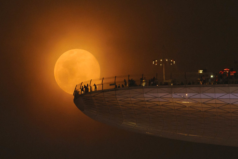
5. Marina Bay Sands Skypark, Singapore

Supermoon

Photograph by Cheng Kiang Ng | ckphoto.net


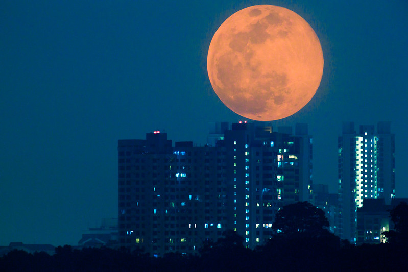
6. Singapore

Supermoon 2013

Photograph by Jeremy Chan


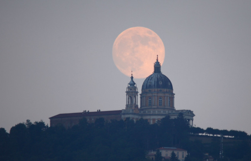
7. Basilica of Superga, Turin, Italy

SuperMoon 2012 and Basilica of Superga

Photograph by Stefano De Rosa


8. Washington D.C.

SuperMoon_2013-06-23

Photograph by Jeff Gamble


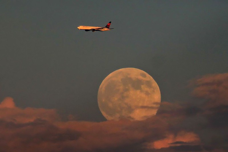
9. South of Seattle, Washington

2013-06-22_4448 E Plane Jumped Over the Moon__filtered

Photograph by np1232 on Flickr


10. Washington Monument

supermoon 2013 (2)

Photograph by NASA/Bill Ingalls


If you enjoyed this post, the Sifter
highly recommends:


iss cupola the window to the world 1 The 2013 Supermoon in Photos


earth rise apollo 11 nasa The 2013 Supermoon in Photos


aurora australis over new zealand tasman sea nasa The 2013 Supermoon in Photos


Picture of the Day: Planet Mercury

$
0
0


PLANET MERCURY


mercury Picture of the Day: Planet Mercury


This colorful view of Mercury was produced by using images from the color base map imaging campaign during MESSENGER’s primary mission. These colors are not what Mercury would look like to the human eye, but rather the colors enhance the chemical, mineralogical, and physical differences between the rocks that make up Mercury’s surface.

Young crater rays, extending radially from fresh impact craters, appear light blue or white. Medium- and dark-blue areas are a geologic unit of Mercury’s crust known as the “low-reflectance material”, thought to be rich in a dark, opaque mineral. Tan areas are plains formed by eruption of highly fluid lavas. The giant Caloris basin is the large circular tan feature located just to the upper right of center of the image.

The MESSENGER spacecraft is the first ever to orbit the planet Mercury, and the spacecraft’s seven scientific instruments and radio science investigation are unraveling the history and evolution of the Solar System’s innermost planet. During the one-year primary mission, MESSENGER acquired 88,746 images and extensive other data sets. MESSENGER is now in a yearlong extended mission.

Mercury is the smallest and closest to the Sun of the eight planets in the Solar System, with an orbital period of about 88 Earth days. Because it has almost no atmosphere to retain heat, Mercury’s surface experiences the greatest temperature variation of all the planets, ranging from 100 K (−173 °C; −280 °F) at night to 700 K (427 °C; 800 °F) during the day at some equatorial regions. [Source]


picture of the day button Picture of the Day: Planet Mercury


Picture of the Day: Flooding in Thailand – Before and After

$
0
0


Flooding in Thailand – Before & After


flooding before and after satellite images from space thailand nasa Picture of the Day: Flooding in Thailand   Before and After


In this true-colour satellite image, we see flooding in Ayutthaya and Pathum Thani Provinces in Central Thailand (right), compared to before the flooding (left).

The Chao Phraya River forms at the confluence of smaller rivers in central Thailand, and flows southward to the Gulf of Thailand. En route to the sea, the river passes through Ayutthaya. First established in the fourteenth century, Ayutthaya lies north of Thailand’s capital city of Bangkok, and the floods plaguing Thailand in October 2011 did not spare this historic city.

The Advanced Land Imager (ALI) on NASA’s Earth Observing-1 (EO-1) satellite acquired these natural-color images of Ayutthaya on October 23, 2011 (right), and July 11, 2011 (left). In both images, the Chao Phraya River curves through the southwestern part of the city. In October, however, the river has overflowed onto nearby floodplains, especially southwest of the river and west of Route 356. Fields, roads, and buildings have all been submerged by sediment-clogged flood water.

Thailand’s monsoon generally lasts from mid-May to September. Because these images show the region at different times of year, some of the differences in water and vegetation could result from normal seasonal variations. However, the large expanse of flood water in October 2011 is unusual even in a monsoon season.

Flooding forced the closure of manufacturing plants in Ayutthaya, according to news reports. The city is a United Nations Educational, Scientific and Cultural Organization (UNESCO) World Heritage site.


picture of the day button Picture of the Day: Flooding in Thailand   Before and After


15 Volcanic Eruptions as Seen from Space

$
0
0


A volcano is an opening, or rupture, in a planet’s surface or crust, which allows hot magma, volcanic ash and gases to escape from the magma chamber below the surface.

They are generally found where tectonic plates are diverging or converging. A mid-oceanic ridge, for example the Mid-Atlantic Ridge, has examples of volcanoes caused by divergent tectonic plates pulling apart; the Pacific Ring of Fire has examples of volcanoes caused by convergent tectonic plates coming together. Volcanoes can also form where there is stretching and thinning of the Earth’s crust in the interiors of plates.

There is no consensus among volcanologists on how to define an “active” volcano. The lifespan of a volcano can vary from months to several million years, making such a distinction sometimes meaningless when compared to the lifespans of humans or even civilizations.

Scientists usually consider a volcano to be erupting or likely to erupt if it is currently erupting, or showing signs of unrest such as unusual earthquake activity or significant new gas emissions. Most scientists consider a volcano active if it has erupted in the last 10,000 years (Holocene times). There are about 1500 active volcanoes in the world – the majority along the Pacific Ring of Fire – and around 50 of these erupt each year. An estimated 500 million people live near active volcanoes. [Source]

In the gallery below we look at a selection of Earth’s volcanoes from above. These stunning images were captured from various satellites as well as crew members aboard the International Space Station (ISS). The views from space offer a unique perspective of one of nature’s most awesome and terrifying events.


1. Sarychev Volcano, Russia

sarychev volcano russia from space aerial nasa

Photograph by NASA


A fortuitous orbit of the International Space Station allowed the astronauts this striking view of Sarychev volcano (Russia’s Kuril Islands, northeast of Japan) in an early stage of eruption on June 12, 2009. Sarychev Peak is one of the most active volcanoes in the Kuril Island chain and is located on the northwestern end of Matua Island.
 
Prior to June 12, the last explosive eruption had occurred in 1989 with eruptions in 1986, 1976, 1954 and 1946 also producing lava flows. Commercial airline flights were diverted from the region to minimize the danger of engine failures from ash intake. This detailed photograph is exciting to volcanologists because it captures several phenomena that occur during the earliest stages of an explosive volcanic eruption.
 
The main column is one of a series of plumes that rose above Matua Island (48.1 degrees north latitude and 153.2 degrees east longitude) on June 12. The plume appears to be a combination of brown ash and white steam. The vigorously rising plume gives the steam a bubble-like appearance; the surrounding atmosphere has been shoved up by the shock wave of the eruption. The smooth white cloud on top may be water condensation that resulted from rapid rising and cooling of the air mass above the ash column, and is probably a transient feature (the eruption plume is starting to punch through). The structure also indicates that little to no shearing winds were present at the time to disrupt the plume. By contrast, a cloud of denser, gray ash — most probably a pyroclastic flow — appears to be hugging the ground, descending from the volcano summit. The rising eruption plume casts a shadow to the northwest of the island (bottom center). Brown ash at a lower altitude of the atmosphere spreads out above the ground at upper right. Low-level stratus clouds approach Matua Island from the east, wrapping around the lower slopes of the volcano. Only about 1.5 kilometers of the coastline of Matua Island (upper center) can be seen beneath the clouds and ash.


2. Kliuchevskoi Volcano, Russia

kliuchevskoi volcano kamchatika russia from space aerial nasa

Photograph by NASA


STS068-218-007 (30 September-11 October 1994) — (Kliuchevskoi Volcano) The crewmembers used a 70mm camera to photograph this northeasterly looking view of the plume from the Kamchatka peninsula’s newly erupted volcano. The eruption was photographed from 115 nautical miles above Earth. Six NASA astronauts spent a week and a half aboard the Space Shuttle Endeavour in support of the Space Radar Laboratory 2 (SRL-2) mission.


3. Pavlof Volcano, Alaska

Alaska Pavlof Volcano from space aerial nasa


Astronauts aboard the International Space Station (ISS) photographed these striking views of Pavlof Volcano on May 18, 2013. The oblique perspective from the ISS reveals the three dimensional structure of the ash plume, which is often obscured by the top-down view of most remote sensing satellites.
 
Situated in the Aleutian Arc about 625 miles (1,000 kilometers) southwest of Anchorage, Pavlof began erupting on May 13, 2013. The volcano jetted lava into the air and spewed an ash cloud 20,000 feet (6,000 meters) high. When photograph ISS036-E-2105 (top) was taken, the space station was about 475 miles south-southeast of the volcano (49.1° North latitude, 157.4° West longitude). The volcanic plume extended southeastward over the North Pacific Ocean.


4. Manam Volcano, Papua New Guinea

Manam Volcano, Papua New Guinea from space aerial nasa

Photograph by NASA/Jesse Allen


Papua New Guinea’s Manam Volcano released a thin, faint plume on June 16, 2010, as clouds clustered at the volcano’s summit. The Advanced Land Imager (ALI) on NASA’s Earth Observing-1 (EO-1) satellite took this picture the same day. Rivulets of brown rock interrupt the carpet of green vegetation on the volcano’s slopes. Opaque white clouds partially obscure the satellite’s view of Manam. The clouds may result from water vapor from the volcano, but may also have formed independent of volcanic activity. The volcanic plume appears as a thin, blue-gray veil extending toward the northwest over the Bismarck Sea.
 
Located 13 kilometers (8 miles) off the coast of mainland Papua New Guinea, Manam forms an island 10 kilometers (6 miles) wide. It is a stratovolcano. The volcano has two summit craters, and although both are active, most historical eruptions have arisen from the southern crater.


5. Puyehue-Cordón Caulle Volcano, Chile

Puyehue-Cordon Caulle Volcano chile from space aerial nasa


After awakening on June 4, 2011, the eruption at the Puyehue-Cordón Caulle Volcanic Complex continued through at least June 6th. Located in Chile, just west of the border with Argentina, Puyehue-Cordón Caulle emitted a plume of light-colored ash that stretched along the edge of the Andes. Hours earlier the prevailing winds had shifted, forming the prominent kink visible in the plume.
 
This natural-color satellite image was acquired by the Moderate Resolution Imaging Spectroradiometer (MODIS) aboard Terra on the morning of June 6, 2011. At the time the Buenos Aires Volcanic Ash Advisory Center (VAAC) reported that the ash plume reached an altitude of 40,000 feet (12,000 meters).


6. Eyjafjallajokull Volcano, Iceland

Eyjafjallajokull Volcano, Iceland from space aerial nasa


7. Nyiragongo Volcano, DR Congo

Nyamuragira and Nyiragongo east africa volcano from space aerial nasa

Photograph by NASA


Two East African volcanoes, Nyamuragira and Nyiragongo, account for 40 percent of all recorded eruptions in Africa. The two volcanoes sit along the edge of the Western Rift, part of a giant crack in the Earth’s crust that runs for thousands of miles from the Middle East southward to central Africa. In addition to their shared tendency to produce unusually fast-moving lava flows, the two volcanoes have an even rarer trait in common. The crater of each has periodically contained a lava lake, a huge volume of molten lava pooling in a high-walled summit crater. The lava lakes can drain during eruptions, either spilling over the rim of the crater or bursting from a fissure or vent on the flank.
 
This high-resolution images from the commercial Ikonos satellite shows the craters Nyiragongo. According to the Smithsonian Global Volcanism Program, the most recent lava lake in the Nyamuragira crater drained during an eruption in 1938; the remnants of that activity are the lighter-purple lavas, mostly in the southwestern part of the crater.
 
The lava lake in Nyiragongo has drained and refilled several times during eruptions in the past few decades. Evidence of its simmering presence is provided by the plume of smoke and/or steam that billows from crater. In 2002, Nyiragongo’s lava lake drained during a flank eruption on the southern slopes. That lava flow raced into the city of Goma, killing several dozen people.


8. Shinmoe-dake Volcano, Japan

Shinmoe-dake Volcano Erupts on Kyushu from space aerial nasa


Ash has been the primary hazard from Shinmoe-dake Volcano since it began erupting on January 26, 2011. This natural-color satellite image shows an ash plume stretching eastwards from the volcano, and looping around the city of Miyazaki. The ash has caused flight cancellations, halted trains, and closed schools in the region. The image was acquired by the Moderate Resolution Imaging Spectroradiometer aboard the Terra satellite on February 4, 2011.


9. Merapi Volcano, Indonesia

merapi volcano java from space aerial nasa

Photograph by NASA


At 2,911 meters, the summit of Merapi Volcano and its vigorous steam plume rises above a bank of stratus clouds on its southern flank on August 24, 2003. One of Indonesia’s most active volcanoes, it has been almost continuously active for nearly ten years, including periodic pyroclastic flows (hot ash and rock debris) and avalanches. The volcano is located less than 25 miles north of the city of Yogykarta in central Java. More than 50,000 people live adjacent the treacherous southwestern slope, where volcanic material often sloughs from the unstable summit. Note the deep ravines on the eastern slopes providing rich soils and moisture to the agriculture below.


10. Api Volcano, Indonesia

api volcano from space aerial nasa

Photograph by NASA


11. Mt. Etna, Italy

mt etna sicily italy volcano from space aerial nasa

Photograph by NASA


When this southward-looking photograph was taken by the Expedition 2 crew aboard the International Space Station, the city of Catania (in shadow, ~25 km SSE of the volcano) was covered by a layer of ash and Fontanarossa International Airport was closed. On that day an ash cloud was reported to have reached a maximum height of ~5.2 km. Plumes from two sources are visible here–a dense, darker mass from one of the three summit craters and a lighter, lower one. The record of historical volcanism of Mt. Etna is one of the longest in the world, dating back to 1500 BC. Two styles of activity are typical: explosive eruptions, sometimes with minor lava flows, from the summit craters and flank eruptions from fissures.


12. Eyjafjallajokull Volcano, Iceland

Eyjafjallajokull Volcano Iceland from space aerial nasa


NASA’s Terra satellite flew over the Eyjafjallajokull Volcano, Iceland, on May 6 at 11:55 UTC (7:55 a.m. EDT). The Moderate Resolution Imaging Spectroradiometer instrument known as MODIS that flies onboard Terra, captured a visible image of the ash plume. The plume was blowing east then southeast over the Northern Atlantic. The satellite image shows that the plume is at a lower level in the atmosphere than the clouds that lie to its east, as the brown plume appears to slide underneath the white clouds.


13. Chaiten Volcano, Chile

chaiten volcano chile from space aerial nasa

Photograph by NASA


After more than 9,000 years of silence, Chaiten Volcano in southern Chile erupted on May 2, 2008. The plume of ash and steam rose 10.7 to 16.8 kilometers (35,000 to 55,000 feet) into the atmosphere, reported the Smithsonian’s Global Volcanism Program. According to news reports issued by the AFP news service, ash blanketed the town of Chaiten, 10 kilometers away, forcing the town’s 4,000 people to evacuate by boat.
 
On May 3, ash and steam continued to billow from the volcano. The Moderate Resolution Imaging Spectroradiometer on NASA’s Terra satellite captured this photo-like image of a long, cloud-like plume flowing southeast from the volcano’s summit on May 3 at 10:35 a.m. local time (14:35 UTC). The plume rises high over the Andes Mountains, drifts across Argentina, and dissipates over the Atlantic Ocean. Ash closed schools, roads, and an airport in Argentina, hundreds of kilometers away from the volcano, said AFP.


14. Kliuchevskoi Volcano, Russia

kliuchevskoi volcano kamchatika russia from space aerial nasa 2

Photograph by NASA


STS068-214-035 (30 September 1994) — One of the first photos taken by the crewmembers on launch day of the Space Shuttle Endeavour was this 70mm frame of the Kliuchevskoi volcano on the Kamchatka Peninsula in Russia. The volcano was near its peak at this time. The large, black eruption plume billows from the summit, as ash is being deposited on the snow-covered region to the east and southeast (north is to upper left). A small steam plume rises from the peak of Bezymianny just south of Kliuchevskoi (or just right of center). As various members of the six-person crew were using handheld cameras to record the eruption, hardware in Endeavour’s cargo bay was taking radar data of the event in support of the Space Radar Laboratory (SRL-2) project.


15. Pavlof Volcano, Alaska

Alaska Pavlof Volcano from space aerial nasa 2


Astronauts aboard the International Space Station (ISS) photographed these striking views of Pavlof Volcano on May 18, 2013. The oblique perspective from the ISS reveals the three dimensional structure of the ash plume, which is often obscured by the top-down view of most remote sensing satellites.
 
Situated in the Aleutian Arc about 625 miles (1,000 kilometers) southwest of Anchorage, Pavlof began erupting on May 13, 2013. The volcano jetted lava into the air and spewed an ash cloud 20,000 feet (6,000 meters) high. When photograph ISS036-E-2105 (top) was taken, the space station was about 475 miles south-southeast of the volcano (49.1° North latitude, 157.4° West longitude). The volcanic plume extended southeastward over the North Pacific Ocean.


If you enjoyed this post, the Sifter
highly recommends:


roll cloud uruguay 15 Volcanic Eruptions as Seen from Space


mergui archipelago myanmar landsat satellite image 15 Volcanic Eruptions as Seen from Space


7619774996 819725d4d4 c 15 Volcanic Eruptions as Seen from Space


crab nebula nasa 15 Volcanic Eruptions as Seen from Space


Picture of the Day: Earth from the Dark Side of Saturn

$
0
0


EARTH FROM THE DARK SIDE OF SATURN


earth from dark side of saturn nasa you are here Picture of the Day: Earth from the Dark Side of Saturn


In this rare image taken on July 19, 2013, the wide-angle camera on NASA’s Cassini spacecraft has captured Saturn’s rings and our planet Earth and its moon in the same frame.

The dark side of Saturn, its bright limb, the main rings, the F ring, and the G and E rings are clearly seen; the limb of Saturn and the F ring are overexposed. The “breaks” in the brightness of Saturn’s limb are due to the shadows of the rings on the globe of Saturn, preventing sunlight from shining through the atmosphere in those regions. The E and G rings have been brightened for better visibility.

Earth, which is 898 million miles (1.44 billion kilometers) away in this image, appears as a blue dot at center right; the moon can be seen as a fainter protrusion off its right side. An arrow indicates their location. The other bright dots nearby are stars.

This is only the third time ever that Earth has been imaged from the outer solar system. The acquisition of this image marked the first time that inhabitants of Earth knew in advance that their planet was being imaged. That opportunity allowed people around the world to join together in social events to celebrate the occasion.

The image was taken using red, green and blue spectral filters were combined to create this natural color view. The images were obtained with the Cassini spacecraft wide-angle camera on July 19, 2013 at a distance of approximately 753,000 miles (1.212 million kilometers) from Saturn.

The Cassini-Huygens mission is a cooperative project of NASA, the European Space Agency and the Italian Space Agency. The Jet Propulsion Laboratory, a division of the California Institute of Technology in Pasadena, manages the mission for NASA’s Science Mission Directorate, Washington, D.C. The Cassini orbiter and its two onboard cameras were designed, developed and assembled at JPL. The imaging operations center is based at the Space Science Institute in Boulder, Colo.

For more information about the Cassini-Huygens mission visit www.nasa.gov/cassini and saturn.jpl.nasa.gov


picture of the day button Picture of the Day: Earth from the Dark Side of Saturn


Picture of the Day: A Rose Made of Galaxies

$
0
0


A ROSE MADE OF GALAXIES


rose made of galaxies Picture of the Day: A Rose Made of Galaxies

Photograph by NASA/ESA/STScI/AURA


In celebration of the 21st anniversary of the Hubble Space Telescope’s deployment into space, astronomers at the Space Telescope Science Institute in Baltimore, Md., pointed Hubble’s eye to an especially photogenic group of interacting galaxies called Arp 273.

The larger of the spiral galaxies, known as UGC 1810, has a disk that is tidally distorted into a rose-like shape by the gravitational tidal pull of the companion galaxy below it, known as UGC 1813. A swath of blue jewels across the top is the combined light from clusters of intensely bright and hot young blue stars. These massive stars glow fiercely in ultraviolet light.

The smaller, nearly edge-on companion shows distinct signs of intense star formation at its nucleus, perhaps triggered by the encounter with the companion galaxy.

A series of uncommon spiral patterns in the large galaxy is a tell-tale sign of interaction. The large, outer arm appears partially as a ring, a feature seen when interacting galaxies actually pass through one another. This suggests that the smaller companion actually dived deep, but off-center, through UGC 1810. The inner set of spiral arms is highly warped out of the plane with one of the arms going behind the bulge and coming back out the other side. How these two spiral patterns connect is still not precisely known.

The larger galaxy in the UGC 1810 – UGC 1813 pair has a mass that is about five times that of the smaller galaxy. In unequal pairs such as this, the relatively rapid passage of a companion galaxy produces the lopsided or asymmetric structure in the main spiral. Also in such encounters, the starburst activity typically begins in the minor galaxies earlier than in the major galaxies. These effects could be due to the fact that the smaller galaxies have consumed less of the gas present in their nucleus, from which new stars are born.

Arp 273 lies in the constellation Andromeda and is roughly 300 million light-years away from Earth. The image shows a tenuous tidal bridge of material between the two galaxies that are separated by tens of thousands of light-years from each other. The interaction was imaged on December 17, 2010, with Hubble’s Wide Field Camera 3 (WFC3).

This Hubble image is a composite of data taken with three separate filters on WFC3 that allow a broad range of wavelengths covering the ultraviolet, blue, and red portions of the spectrum.


picture of the day button Picture of the Day: A Rose Made of Galaxies


Picture of the Day: The Eclipse of Venus

$
0
0


THE ECLIPSE OF VENUS


venus planetary eclipse Picture of the Day: The Eclipse of Venus

Image Credit: NASA/SDO & the AIA, EVE, and HMI teams
Digital Composition by: PETER L. DOVE


Selected as NASA’s Astronomy Picture of the Day on August 20, 2013, is this fascinating digital composition by Peter L. Dove. APOD explains:

Usually it is the Earth’s Moon that eclipses the Sun. Last June, most unusually, the planet Venus took a turn. Like a solar eclipse by the Moon, the phase of Venus became a continually thinner crescent as Venus became increasingly better aligned with the Sun.
 
Eventually the alignment became perfect and the phase of Venus dropped to zero. The dark spot of Venus crossed our parent star. The situation could technically be labeled a Venusian annular eclipse with an extraordinarily large ring of fire. Pictured above during the occultation, the Sun was imaged in three colors of ultraviolet light by the Earth-orbiting Solar Dynamics Observatory, with the dark region toward the right corresponding to a coronal hole. Hours later, as Venus continued in its orbit, a slight crescent phase appeared again. The next Venusian solar eclipse will occur in 2117.


picture of the day button Picture of the Day: The Eclipse of Venus


Picture of the Day: One Giant Leap

$
0
0


ONE GIANT LEAP


frog nasa photobomb rocket launch one giant leap Picture of the Day: One Giant Leap


Last Friday a frog managed to photobomb a NASA spacecraft launch. Posted earlier this week to NASA’s Goddard Space Flight Center Flickr page, NASA explains:

“A still camera on a sound trigger captured this intriguing photo of an airborne frog as NASA’s LADEE spacecraft lifts off from Pad 0B at Wallops Flight Facility in Virginia. The photo team confirms the frog is real and was captured in a single frame by one of the remote cameras used to photograph the launch. The condition of the frog, however, is uncertain.”


Below is a close-up of the same image for those interested. Godspeed little frog.

For more fascinating imagery, be sure to check out NASA Goddard Space Flight Center on Flickr, it’s without doubt, one of the best accounts!


frog nasa photobomb rocket launch one giant leap close up Picture of the Day: One Giant Leap


picture of the day button Picture of the Day: One Giant Leap


Picture of the Day: The First Untethered Free Flight in Space

$
0
0


THE FIRST UNTETHERED FREE FLIGHT IN SPACE


Bruce McCandless II free flying in space floating untethered

Photograph by NASA


In this mind-blowing photograph, taken 12 February 1984, Mission Specialist Bruce McCandless II, is seen further away from the confines and safety of his ship than any previous astronaut had ever been. This ‘space first’ was made possible by the Manned Maneuvering Unit or MMU, a nitrogen jet propelled backpack.

After a series of test maneuvers inside and above Challenger’s payload bay, McCandless went free-flying to a distance of 320 feet (97.5 m) away from the Orbiter. This stunning orbital panorama view shows McCandless out there amongst the black and blue of Earth and space.

During his career McCandless logged over 312 hours in space. He was a member of the astronaut support crew for the Apollo 14 mission, served as CAPCOM during the Apollo 11 mission when Neil Armstrong first set his foot on the Moon, and was backup pilot for the first manned Skylab mission (SL-1/SL-2). And of course he completed the first ever untethered free flight in space. [Source]


picture of the day button Picture of the Day: The First Untethered Free Flight in Space


Picture of the Day: A Canyon of Fire on the Sun

$
0
0


A CANYON OF FIRE ON THE SUN


Filament Eruption Creates 'Canyon of Fire' on the Sun

Photograph by NASA/SDO


NASA/SDO – A magnetic filament of solar material erupted on the sun in late September, breaking the quiet conditions in a spectacular fashion. The 200,000 mile long filament ripped through the sun’s atmosphere, the corona, leaving behind what looks like a canyon of fire. The glowing canyon traces the channel where magnetic fields held the filament aloft before the explosion. Visualizers at NASA’s Goddard Space Flight Center in Greenbelt, Md. combined two days of satellite data to create a short movie of this gigantic event on the sun (seen here).

In reality, the sun is not made of fire, but of something called plasma: particles so hot that their electrons have boiled off, creating a charged gas that is interwoven with magnetic fields. These images were captured on Sept. 29-30, 2013, by NASA’s Solar Dynamics Observatory, or SDO, which constantly observes the sun in a variety of wavelengths.

Different wavelengths help capture different aspect of events in the corona. The red images shown in the movie help highlight plasma at temperatures of 90,000° F and are good for observing filaments as they form and erupt. The yellow images, showing temperatures at 1,000,000° F, are useful for observing material coursing along the sun’s magnetic field lines, seen in the movie as an arcade of loops across the area of the eruption. The browner images at the beginning of the movie show material at temperatures of 1,800,000° F, and it is here where the canyon of fire imagery is most obvious. By comparing this with the other colors, one sees that the two swirling ribbons moving farther away from each other are, in fact, the footprints of the giant magnetic field loops, which are growing and expanding as the filament pulls them upward. [Source]


picture of the day button Picture of the Day: A Canyon of Fire on the Sun


Picture of the Day: In Awe of the Aurora

$
0
0


IN AWE OF THE AURORA


aurora astralis from iss space expedition 23 Picture of the Day: In Awe of the Aurora

Photograph by NASA


NASA ISS023-E-058455 (29 May 2010) – Aurora Australis is featured in this image photographed by an Expedition 23 crew member on the International Space Station. Among the views of Earth afforded crew members aboard the ISS, surely one of the most spectacular is of the aurora. These ever-shifting displays of colored ribbons, curtains, rays, and spots are most visible near the North (Aurora Borealis) and South (Aurora Australis) Poles as charged particles streaming from the sun (the solar wind) interact with Earth’s magnetic field, resulting in collisions with atoms of oxygen and nitrogen in the upper atmosphere.

The atoms are excited by these collisions, and typically emit photons as a means of returning to their original energy state. The photons form the aurora that we see. The most commonly observed color of aurora is green, caused by photons (light) emitted by excited oxygen atoms at wavelengths centered at 0.558 micrometers, or millionths of a meter. Visible light is reflected from healthy (green) plant leaves at approximately the same wavelength. Red auroras are generated by light emitted at a longer wavelength (0.630 micrometers), and other colors such as blue and purple are also sometimes observed.

While auroras are generally only visible close to the poles, severe magnetic storms impacting Earth’s magnetic field can shift them towards the equator. This striking aurora image was taken during a geomagnetic storm that was most likely caused by a coronal mass ejection from the sun on May 24, 2010. The ISS was located over the Southern Indian Ocean at an altitude of 350 kilometers, with the observer most likely looking towards Antarctica (not visible) and the South Pole. The aurora has a sinuous ribbon shape that separates into discrete spots near the lower right corner of the image.

While the dominant coloration of the aurora is green, there are faint suggestions of red photon emission as well (light fuscia tones at center left). Dense cloud cover is dimly visible below the aurora. The curvature of Earth’s horizon, or limb, is clearly visible as is the faint blue line of the upper atmosphere directly above at top center. Several stars appear as bright pinpoints against the blackness of space at top right. [Source: NASA]


picture of the day button Picture of the Day: In Awe of the Aurora


Saturn, Venus, Mars and Earth All in One Photo

$
0
0

saturn by nasa original

Photograph by NASA/JPL-Caltech/SSI


For a sense of scale, the image above sweeps nearly 405,000 miles (651,784 km) across Saturn and its inner rings. It’s the first image ever taken that shows Saturn, its moons and rings, Venus, Mars and Earth all at once. Unveiled on Tuesday, the natural-color, panoramic mosaic taken by NASA’s Cassini spacecraft shows the view as it would be seen by human eyes.


saturn nasa

Photograph by NASA/JPL-Caltech/SSI


With both Cassini’s wide-angle and narrow-angle cameras aimed at Saturn, Cassini was able to capture 323 images in just over four hours. This final mosaic uses 141 of those wide-angle images. Images taken using the red, green and blue spectral filters of the wide-angle camera were combined and mosaicked together to create this natural-color view. [Source]


saturn venus mars earth in one photo nasa

Photograph by NASA/JPL-Caltech/SSI


saturn venus mars earth in one photo

Photograph by NASA/JPL-Caltech/SSI


In the lower right of the mosaic, in between the bright blue E ring and the faint but defined G ring, is the pale blue dot of our planet, Earth. Look closely and you can see the moon protruding from the Earth’s lower right (click here for 9000×3500 px resolution). Earth’s twin, Venus, appears as a bright white dot in the upper left quadrant of the mosaic, also between the G and E rings. Mars also appears as a faint red dot embedded in the outer edge of the E ring, above and to the left of Venus. For ease of visibility, Earth, Venus, Mars, Enceladus, Epimetheus and Pandora were all brightened by a factor of eight and a half relative to Saturn. [Source]


saturn earth and moon in one shot close up nasa

Photograph by NASA/JPL-Caltech/SSI


saturn mars and venus in one shot close up nasa

Photograph by NASA/JPL-Caltech/SSI


A third annotated version of the image (click here for the 9000×3500 px version) labels Saturn’s numerous rings and moons such as: Enceladus, Prometheus, Tethys, Mimas, Pandora, Epimetheus, Janus, Janus’ ring and Pallene’s ring. [Source]


saturn with celestial bodies labelled

Photograph by NASA/JPL-Caltech/SSI


saturn labelled cropped

Photograph by NASA/JPL-Caltech/SSI


Cassini was approximately 746,000 miles (1.2 million kilometers) from Saturn when the images in this mosaic were taken. Launched in 1997, Cassini has explored the Saturn system for more than nine years. NASA plans to continue the mission through 2017, with the anticipation of many more images of Saturn, its rings and moons, as well as other scientific data. [Source]


If you enjoyed this post, the Sifter
highly recommends:


if jupiter was as close to earth as the moon Saturn, Venus, Mars and Earth All in One Photo


crab nebula nasa Saturn, Venus, Mars and Earth All in One Photo


earth rise apollo 11 nasa Saturn, Venus, Mars and Earth All in One Photo


Picture of the Day: This Star Cluster is 12 Billion Years Old

$
0
0


THIS STAR CLUSTER IS
12 BILLION YEARS OLD


messier 15 globular star cluster Picture of the Day: This Star Cluster is 12 Billion Years Old

Photograph by NASA/ESA


[NASA/ESA] – This cluster of stars is known as Messier 15, and is located some 35 000 light-years away in the constellation of Pegasus (The Winged Horse). It is one of the oldest globular clusters known, with an age of around 12 billion years.

Both very hot blue stars and cooler golden stars can be seen swarming together in the image, becoming more concentrated towards the cluster’s bright centre. Messier 15 is one of the densest globular clusters known, with most of its mass concentrated at its core. As well as stars, Messier 15 was the first cluster known to host a planetary nebula, and it has been found to have a rare type of black hole at its centre.

This new image is made up of observations from Hubble’s Wide Field Camera 3 and Advanced Camera for Surveys in the ultraviolet, infrared, and optical parts of the spectrum. To see the full 3749 x 4028 px image, visit spacetelescope.org

A globular cluster is a spherical collection of stars that orbits a galactic core as a satellite. Globular clusters are very tightly bound by gravity, which gives them their spherical shapes and relatively high stellar densities toward their centers. There are currently 150 – 158 known globular clusters in the Milky Way Galaxy alone. [Source]


picture of the day button Picture of the Day: This Star Cluster is 12 Billion Years Old


This Image Really Puts the Size of Antarctica Into Perspective

$
0
0

antarctica from space nasa (1)


Seen above is a view of the Earth on September 21, 2005 with the full Antarctic region visible. The composite image shows the sea ice on September 21, 2005, the date at which the sea ice was at its minimum extent in the northern hemisphere. The colour of the sea ice is derived from the AMSR-E 89 GHz brightness temperature while the extent of the sea ice was determined by the AMSR-E sea ice concentration. Over the continents, the terrain shows the average land cover for September, 2004. The global cloud cover shown was obtained from the original Blue Marble cloud data distributed in 2002. [Source]

Due to the position of Antarctica in relation to our Sun it would not look like this to the naked eye. This is a composite that shows what Antarctica looks like if the entire continent were illuminated.

Click here for the full resolution 8400×8400 pixel TIFF version (63 mb) and click here for the 8400 x 8400 px JPG version.

Antarctica is Earth’s southernmost continent and is surrounded by the Southern Ocean. At 14.0 million km2 (5.4 million sq mi), it is the fifth-largest continent in area after Asia, Africa, North America, and South America. About 98% of Antarctica is covered by ice that averages at least 1 mile (1.6 km) in thickness, which extends to all but the northernmost reaches of the Antarctic Peninsula. [Source]

Antarctica, on average, is the coldest, driest, and windiest continent, and has the highest average elevation of all the continents. Antarctica is considered a desert, with annual precipitation of only 200 mm (8 inches) along the coast and far less inland. The temperature in Antarctica has reached −89 °C (−129 °F). There are no permanent human residents, but anywhere from 1,000 to 5,000 people reside throughout the year at the research stations scattered across the continent. [Source]

Below are other images of our beautiful planet by NASA that show other continents and areas of the globe for comparison.


planet earth from space nasa (4)


planet earth from space nasa (2)


planet earth from space nasa (3)


planet earth from space nasa (1)


antarctica from space nasa This Image Really Puts the Size of Antarctica Into Perspective


If you enjoyed this post, the Sifter
highly recommends:


if saturn was as close to earth as the moon This Image Really Puts the Size of Antarctica Into Perspective


sarychev volcano russia from space aerial nasa This Image Really Puts the Size of Antarctica Into Perspective


iss cupola the window to the world 15 This Image Really Puts the Size of Antarctica Into Perspective


Viewing all 222 articles
Browse latest View live


Latest Images